Tectonic Evolution of the Sharbazher Area: Fold–Thrust Belts, Fault Systems, and Uplift History in the Northwestern Zagros Orogen
Abstract
The Sharbazher area, located in the northwestern segment of the Zagros Mountain Belt, represents a key geological region formed by the ongoing convergence between the Arabian and Eurasian plates. This study examines the tectonic evolution of the Sharbazher area with a focus on fold–thrust belt development, major fault systems, and the uplift history that shaped its present-day mountainous landscape. The region lies near the boundary between the Arabian Plate and the Zagros suture zone, where intense compressional tectonics since the Late Cretaceous have produced complex structural architectures. Field observations, stratigraphic relationships, and regional tectonic synthesis indicate that progressive shortening, thrust stacking, and crustal thickening have played a dominant role in the uplift of the Sharbazher mountains. The results highlight the scientific importance of Sharbazher as a natural laboratory for understanding continental collision processes in the Zagros Orogen and support its significance as a core geological area within the proposed Sharbazher Geopark.
Description
1. Regional Tectonic Setting
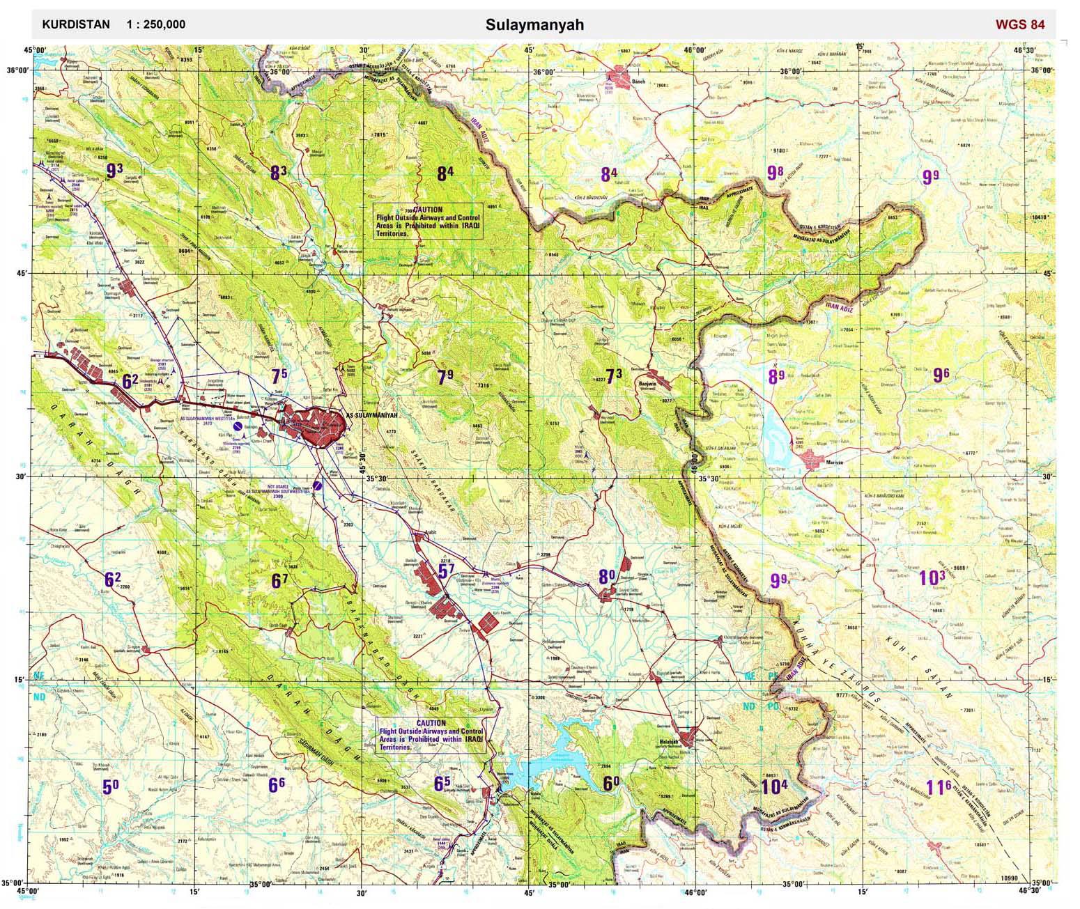
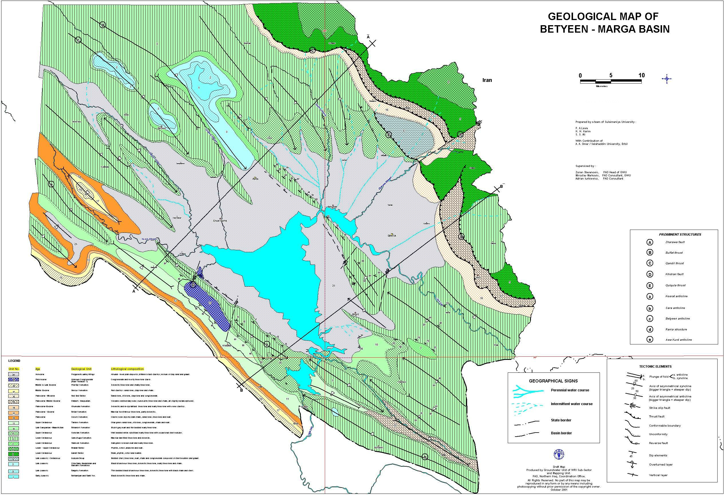
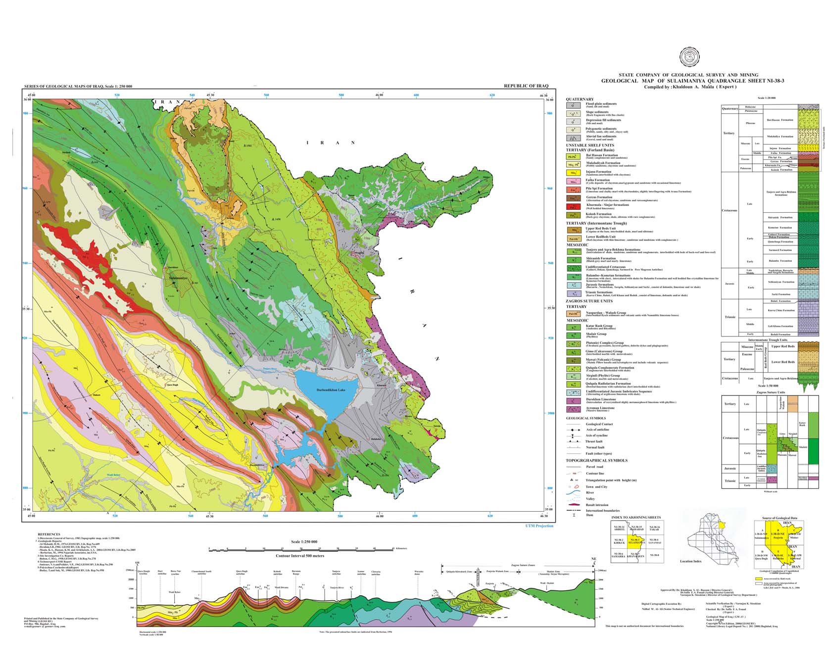
The Sharbazher area is situated within the High Folded and Imbricated Zones of the Zagros Mountains, forming part of the broader Alpine–Himalayan orogenic belt. This region developed as a direct consequence of the northward movement of the Arabian Plate and its collision with the Eurasian Plate. The closure of the Neo-Tethys Ocean during the Late Cretaceous to Cenozoic marked the beginning of intense compressional deformation that continues today. Sharbazher occupies a strategic position near the Zagros suture zone, where remnants of oceanic crust and ophiolitic complexes are preserved, indicating former oceanic domains before continental collision.
2. Development of Fold–Thrust Belts
One of the most prominent tectonic features of the Sharbazher area is the well-developed fold–thrust belt. Thick sedimentary successions, ranging from deep marine to shallow marine and continental deposits, were progressively shortened and deformed during plate convergence. This resulted in large-scale anticlines and synclines, many of which are asymmetrical and fault-related. Thrust faults commonly place older rocks over younger formations, forming imbricated structures characteristic of the Zagros orogen. These folds and thrusts control much of the present-day topography, influencing valley formation, mountain ridges, and drainage patterns.
3. Fault Systems and Structural Controls
Several generations of faults have been identified in the Sharbazher area, reflecting different tectonic phases. Early extensional faults related to basin development were later reactivated as reverse or thrust faults during compression. Major thrust faults accommodate significant crustal shortening, while strike-slip and oblique-slip faults locally modify fold geometries and create structural complexities. These fault systems not only record the tectonic evolution of the region but also play an important role in groundwater circulation, slope instability, and landscape development.
4. Uplift History and Landscape Evolution
The uplift of the Sharbazher mountains is closely linked to crustal thickening caused by thrust stacking and deep-seated shortening within the Arabian Plate margin. Uplift intensified during the Cenozoic, particularly from the Miocene onwards, leading to rapid erosion and the development of deeply incised valleys. This uplift–erosion interaction produced spectacular geomorphological features such as steep mountain fronts, gorges, and elevated plateaus. Ongoing tectonic activity is evidenced by active faults, seismicity, and continued landscape rejuvenation, confirming that Sharbazher remains part of an active orogenic system.
5. Scientific and Geopark Significance
The tectonic evolution of the Sharbazher area provides critical insights into continental collision processes, fold–thrust belt dynamics, and mountain-building mechanisms in the Zagros Orogen. The clear exposure of folded strata, thrust faults, suture-related rocks, and uplifted terrains makes Sharbazher an exceptional outdoor geological classroom. These characteristics strongly support its inclusion as a key geosite cluster within the proposed Sharbazher Geopark, contributing to geoscience education, research, and sustainable geotourism.
References
Cultural Heritage in the National Park & Geopark of Sharbazher (University of Sulaimani)
Archaeology and Geopark Context of Sharbazher District
Geosites Requirements and Geological Values of Sharbazher Area
UNESCO-Aligned Geopark Website and Geology Content Checklist
Image Gallery